


As longtime readers know, I’m a sucker for maps. So when someone puts together an interactive compilation of connectivity covering virtually every active or planned undersea cable on the planet, I take notice. The folks over at Telegeography did that earlier today, combining their extensive database with some really nice and lightweight javascript mapping software and offering it up for free.
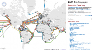
It’s an impressive effort that I’ve added to my Other Map Collections page. One thing that makes this sort of map possible is that subsea fiber maps usually only have a few generally static endpoints, and of those many are shared. Likewise, the actual path of the fiber under the water isn’t critical and therefore doesn’t need to be represented, so you can concentrate on who connects what endpoints and at what speed.
For terrestrial networks, this sort of interactive map would get messy after just a few networks are overlaid. Nevertheless, I’ve been looking for some sort of way to put together terrestrial network data that does what Telegeography’s subsea map does – perhaps someone will solve that problem one day too.
If you haven't already, please take our Reader Survey! Just 3 questions to help us better understand who is reading Telecom Ramblings so we can serve you better!
Categories: Undersea cables
Discuss this Post